Across the Empire State

image

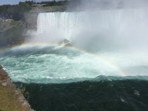
I re-entered the States into New York at Niagara Falls after a week peddling through Ontario. The guy at the U.S. border was more interested in my trip than whether I was bringing in any problems – he seemed incredulous that I had come all the way from Seattle.  I’m experiencing that reaction more and more the farther East I get – people will say, “No way, you must have flown here,” or similar comments. It is beyond most folks’ comprehension to accept that a skinny, 63-year-old guy from Seattle could bicycle across the Continent, now more than 4000 miles into the trip!

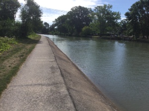
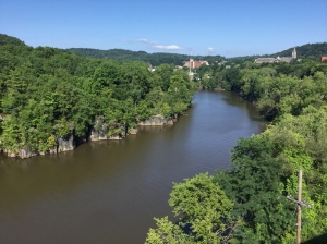
After landing at Lockport, NY, the first stop on the Erie Canal north and east from Buffalo, I had the privilege and delight to bicycle along the tow path of the historic Erie Canal most of my way through upstate New York.  What an amazing place and a wonderful, historical experience. Plus it was mostly flat, following along the edge of the canal, which is a benefit to the bicyclist passing through the hilly ridges between the Finger Lakes.

image

(The lock at Lockport, one of the highest lifts on the old Erie Canal.)


image

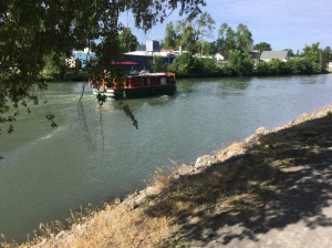
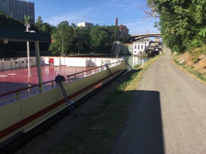
(Canal boats move up-stream on the Erie Canal.)


image

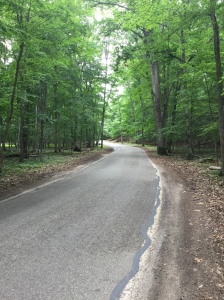
(One has to be careful while peddling on certain sections of the old tow path, lest one were to vere right…)


The Erie Canal was built in the early 1800s to connect the eastern Hudson River settlements with the “West” represented by Lake Erie at that time. The path rose 500 feet in total elevation from the Hudson to Lake Erie, and involved 50 locks.  It was a feat of engineering as well as physical labor, and was considered one of the engineering “wonders of the world” at its opening in 1824.  I remember my dad, an MIT engineer from the class of 1933, talking about studying this project as well as the Panama Canal – he would have enjoyed coming along on my ride through this section, and probably did from above.


image

(The Canal passes through a lot of small towns that grew up with the canal’s commerce in the 1800s – some are adapting, while others are dwindling.)


image

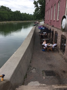
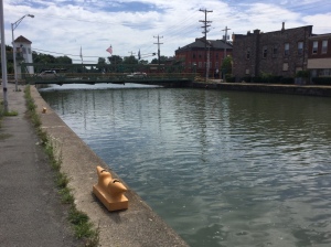
(Here is an adapting town, Brockport, with a brew-pub, Stoneyard Brewing Co., along the edge. The tables in this alley are actually lower than the water in the Canal!)


I passed Rochester and landed one night at Palmyra, NY.  You might recognize this town as the place where Joseph Smith had his conversations with salamanders and found the Mormon tablets. I suspect there are some good mushrooms in these woods.  The town is pretty quiet, but interesting as one of few I’ve ever seen with a church on all four corners of the downtown intersection (at Church and Main, of course). The folks in the local bar that was still open when I got there were really nice and very supportive of my trip (one woman kept saying that I should go on the Survivors show!).

I met various bicyclists along this route, as well as locals who were impressed with where I’d come from.  One local cyclist took me to the Fairport Brewing Company and bought me their best IPA, which was quite good. I wish I had more time to stop and dwell in these small canal towns with so much history – even at my relatively slow pace I feel like I’m traveling too fast.

I skirted Syracuse, including getting off my all-steel bike when a lightening bolt hit too close for comfort.  My colleague, Andrew Radin, from the Product Stewardship Institute board came to my rescue, and we spent a great evening out on one of the Finger Lakes, Skaneateles (pronounced “scan- e-at-e-les”), where his family has a cabin. Wow, what a beautiful place – I wished that I had more time to explore.

image


I had my first flat tire of the trip just as I approached Syracuse, on the day my odometer turned 4000 miles!  I was so surprised I had trouble dealing with it for a few minutes – of course it happened in a pouring rain.  I ducked under a covered lumber yard and changed the tube, realizing upon inspection that I had completely worn through the rear tire. Next day, I changed the tire out at a wonderful little bike shop in Manlius, NY – the guys there opened early for me, fixed my bike (new rear shift cable as well as tire), and refused payment for their services.  I love these small bike shops across this U.S., they are the foundation of our sport, absolutely awesome.


image

(Little Falls, NY, is an example of a town along the Erie Canal that is in transition – one could sense the old mills and the past, yet one also sensed the possibilities ahead. Note the bedrock along the left side that the canal-makers 200 years ago had to dig through.)


I headed east toward Schenectady when I heard from my friend Virginia’s brother, Jamie, and his wife, Kim. They hosted a visit over night at their house in Galway.  It was a treat to learn about their horse-centered lives involving shoeing as well as rodeos as far as Florida! The nexr morning i rode through beautiful, rolling country as I headed south down the Hudson.

image

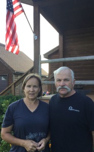
(Road Angels, Kim Breyo and Jamie Felton, of Galway, NY.)


image

I cycled south along the Hudson River, including a long section right along the river though Albany.  I finally crossed the river at the Dunn Memorial Bridge, which had a pedestrian/bicycle path separate from the traffic.  I boogied south along the Hudson through surprisingly rural terrain, with views west into the Catskills.

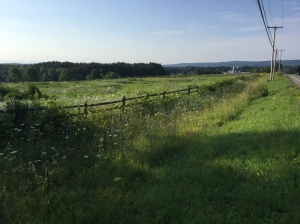
At Germantown, NY, on the Hudson I headed Southeast across the Appalacians and the various hills that got in my way.  I was sure I was not in Kansas when most of the streams that flow to the Hudson were called kills and the ravines they created were called hollows. I rode through Deep Hollow and Bog Hollow.  This was clearly Rip Van Winkle country, although I didn’t come across Sleepy Hollow.  I could have used a long nap that day given the heat, humidity and hills.  Again I was surprised at how rural this region was, less than 100 miles from the big city.

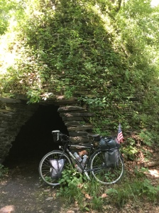
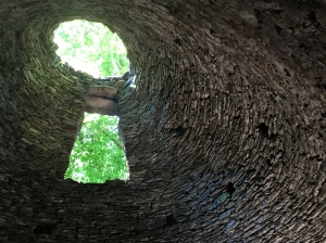
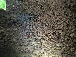
The farther East I get, the older everything seems – roads, buildings, canals, barns, stone walls, whole towns.  Whereas Seattle was settled by pioneers in 1854, most of the villages I’m now peddling through go back at least 100 years earlier, and the closer I get to the coast they start listing their founding dates in the 1600s!  Near the tiny “hamlet” of Wassaic, NY (too small to be officially designated as a village, let alone a town), I noticed some odd rock structures overgrown with ivy by the side of the road. They turned out to be beehive kilns from an old iron works, more than 200 years old.  The beehive construction reminded me of old Celtic ruins we saw in Ireland many years ago. A serendipity moment by the side of Deep Hollow road, seemingly ignored as no big deal by the locals.

image

image

image


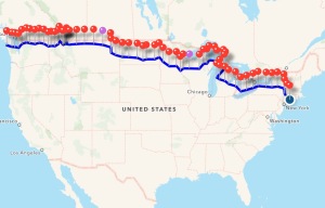
I crossed into Connecticut by such a back road there were no signs, although soon therafter I crossed the Appalachian Trail, a sure indicator to me that I was making progress toward the coast.  And with that I’ll close this post with my latest map showing my progress toward the far corner of Maine. New England states are pretty small compared to most that I’ve traveled through, yet the long Maine coastline still looms.

image


— Dave (posted from New Haven, CT, on 7/31/2016)


In foreign terrain

image

After my farmer’s welcome on my first day in Canada, my short-cut across southern Ontario continued to be a series of pleasant encounters with our northern neighbors.  They seemed even more curious about a lone guy on a bike than many in the States, and were uniformly delighted to hear about my trip and that I had chosen to come through their region for part of it.

This area just north of Lake Erie is mostly dedicated to farmland, right down to the shore.  I was surprised to see so much open land in the region between Toronto and Detroit. Maybe the Canadians are consciously dedicating much of their most southern land to farming, or maybe it makes sense to concentrate industry on Lake Ontario rather than on the north shore of Lake Erie, to save the extra hassles of working through locks for shipping.  Whatever the reason, the land is wide open and productive.  My PBR-drinking farmer grows corn, wheat, sugar beets and soy beans in rotation; other fields in that area had tomatoes; and I saw a few enormous greenhouses bigger than whole city blocks (which we also see in southern British Columbia near Seattle) where winter vegetables can be grown using the relatively cheap Canadian hydropower for heat and light in winter.

image

(Soybeans as far as the eye can see, in southern Ontario.)


image

(Massive hothouses for winter vegetables, in southern Ontario.)


Wind turbines are the other thing quite noticeable about this region. They are everywhere!  There must be good, reliable winds off these Great Lakes and/or significant investments by Canada in wind generation.  Quite impressive.

image

image


I rode through Dresden, Ontario, the home of former slave and author, Josiah Henson, whose memoirs were the inspiration for Harriet Beecher Stowe’s “Uncle Tom’s Cabin.”  Josiah hosted the northern end of the Underground Railroad for those fleeing slaves who wanted to cross into Canada – his acreage was called Dawn Settlement, a place for escaped slaves to resettle.  Cool history that I was unaware of.


Lake Erie, like all the Great Lakes, is huge (I guess that’s why they are called “great”), and reminds me of the ocean but without salt in the air and no tides.  The shore is lovely with small beaches, headlands and bluffs just like along the coast.  In southern Ontario the farmland typically runs right to the bluff, with small towns or a few cottages right along the shore.  My ride was quite scenic as I followed the shore east.

image


I took a side trip one day to visit the town of Ingersoll, Ontario, about 35 miles north of Lake Erie.  This is where my grandmother Everett (my mother’s mother) was born, and where the Everett and Kelly branches of our family tree sprouted in the 1800s.  I wasn’t expecting to run into cousins (I didn’t), but it was still a treat to see the town, which seemed quite prosperous, and the surrounding countryside, which is still mostly farmland but now includes a GM assembly plant among other industries.  The library had a significant section on local history, so I was able to grab some photos of the regional maps from the 1800s to better understand all the small village names in Oxford County that I’ve seen in the genealogy records for long-lost relatives.

image

(The Sacred Heart Church, built in 1838, possibly where my great-grandparents Hiram Everett and Sarah Kelly were married and where my grandmother Lillian was baptized, in Ingersoll, Ontario.)

image

(The prosperous downtown of Ingersoll, Ontario; folks in The Old Bakery were super friendly and supportive – great food, too!)

At the town’s museum, I learned two interesting things. First, Ingersoll was famous for its cheese, so much so that “Ingersoll” was a household name throughout North America and even Europe (like Chedder or Gouda) from the 1850s to the 1960s.  And second, a local guy named Douglas Carr rode his bicycle around the world between 1937 and 1939.  Here are his wheels, now displayed proudly in the Ingersoll museum.

image

(Same basic rig as mine, although with fewer gears and no USB port.)


At Port Erie, I gazed across the beginning of the Niagara River at Buffalo, New York, and rode along a beautiful parkway on the Canadian side of the river heading due north. Around a few corners, I saw mist and heard a roar.  The sight of Niagara Falls is truly spectacular, and on the Canadian side one can almost touch the water just as it flows over the lip of Horseshoe Falls.  I was there on a hot Saturday afternoon in late July, so I shared the experience with thousands of fellow gawkers and selfie-stick wielders speaking many languages.  Quite the tourist moment, but well worth the amazing view.

image

image


I am now back in the States and enjoying my travel along the historic Erie Canal through Upstate New York. More on that in my next installment.  As of this writing, I’m getting closer to the Atlantic and feeling the urge to push harder toward the goal.

image


– Dave (posted 7/26/2016 from Utica, NY)

Many Hearted Michigan

image

“It [Northern Michigan] is a great place to laze around and swim and fish when you want to. And the best place in the world to do nothing. It is beautiful country…. And nobody knows about it but us.”   — Ernest Hemingway


As I rode along the Northwest shore of the lower portion of Michigan (the “Mitt”), I kept finding references to Hemingway, who spent his first 21 summers there, building a collection of stories that would fuel his writings for the rest of his life.  His family had a cabin near Petoskey, and he roamed the area learning to fly fish and soaking up the surly logger personalities of the non-wealthy locals.  These experiences produced his colorful Nick Adams stories, including “Big Two-Hearted River.”  The Two Hearted is actually up in the U.P., and is remembered fondly today through Bell Brewery’s Two Hearted IPA, which has been my beer-of-choice throughout Michigan when I can’t find a more local option to try.

Petoskey today is a quaint town with a permanent population about the same as when E.H. was there 100 years ago, and with a huge summer crowd of tourists.  It is full of lovely old Victorian homes and hotels with many layers of varnish on the aging wood, ice cream bars on almost every corner and expensive boats in the harbor.  A down-state Michigander noted to me, “Oh yeah, that’s where all of Michigan’s moneid crowd goes in the summer.”  That crowd includes Chicago, going back 100 years when visitors would arrive by steamship across Lake Michigan in their flapper dresses and fedora hats. Of note to this ski historian is that Petoskey used to host a huge winter carnival in the 1930s with parades, ice sculptures, ski competitions and other ways to celebrate winter in this cold part of the world.

Also of note from this area are Petoskey stones, fossilized coral commonly found in the area along beaches and dunes.  Tom Gobielle turned me on to Michigan’s state rock which is a local collectors’ item, so I sent him one in an unmarked envelope — truth be told I didn’t want to carry a fossil in my already heavy baggage for the rest of the trip!

image

The towns along this part of the Lake Michigan shore — Harbor Springs, Petoskey, Charlevoix, Traverse City, Leland, Manistee — are prosperous and full of tourists (unlike most of the running-out-of-luck towns I passed through in the U.P.).  Charlevoix in particular had nothing but high-end shops along its main boulevard, catering to a wealthy crowd, at least this time of year.


image

John and Karen Wells welcomed me into their home in Traverse City and served as my tour guides while I took a rest day.  John is an old friend of Dave Waddell, one of my former co-workers. These Angels housed me, fed me, showed me the Sleeping Bear Dunes National Lakeshore and “Fishtown” at Leland, and helped me get repairs done to my bike.  Nice people, indeed.

image

image

[You can see the scale of these dunes when you note the people in the lower photo trying to climb back up from the lake shore!]


As I left John and Karen, I peddled farther south along the lake shore.  Karen had done some historical restoration work on the Point Betsie Lighthouse, so recommended a stop.  Beautiful spot.

image


At the state park in Manistee I ran into Doug and Sue, a couple from Vermont who had ridden cross-country 30 years ago.  Campground Angels, they fed me local IPAs and a wonderful vegetarian dinner (with kale, a veggie I haven’t encountered since Seattle).  A nearby Michigan couple, Jim and Wendy, joined in the bike touring conversation after getting partway around the U.P. on their tandem until they ran into trailer issues. Nice, friendly, supportive people.

image


I crossed lower Michigan on a Southeast diagonal in order to head for Ontario.  In Saginaw, I stayed with Mickey Waddell, Dave’s mom.  At age 85 she reminded me a lot of my own mom, Rita Galvin.  It was a treat to spend time with her.  Yet another Road Angel offering warm hospitality.

image


As I crossed the middle of Michigan, the land changed from rolling hills and lakes to flat farmland.  I was surprised at how much farmland remains even close to the St. Clair River where I expected more industrial settings.  I crossed the St. Clair on a tiny ferry that ran every 15 minutes, at Marine City, MI, into Ontario at Sombra.

image

image

image


Later that day, as I was at about the 95-mile mark of a 102-mile day, a car stopped ahead of me and out popped a local farmer interested in learning where I was from and where I was headed.

image

We talked about my trip and also about his crops and life in that part of Ontario.  As he was about to leave he asked, “Hey, would you like a beer?”  Have I ever been able to say no to that question?  He opened his trunk and pulled out a square “First Aide” box, inside of which were 8 ice-cold beers.  He handed me one and roared off to tend to his corn.  At that moment in the hot afternoon sun, PBR tasted as good as any of the ales I’ve been sampling!  I continue to be amazed at the diversity of Road Angels who pop in and out of my life on this trip.

image


I’m more than two months on the road and have ridden 3700 miles.  Looks promising that I can finish on time to make Bree and Nick’s wedding back in Seattle!

image


— Dave (posted from Port Burwell, Ontario on 7/20/2016)

The U.P., the Mitt and Bob Dylan

“How many roads must a man ride down/ Before you call him a man?”


image

I’m beginning to get my Michigan geography strait after talking with the locals:  there is The Hand (most commonly known as the “U.P.” for “Upper Peninsula”), and there is The Mitt (known as the lower peninsula but never referred to as the “L.P.” and rarely as the Mitt!).  I’ve heard that the population can be divided into two types;  97% are Trolls, living below the bridge, while 3% are Yoopers, living above the bridge.  Those in the U.P. fondly call themselves “Yoopers” and claim that “Life is different above the Bridge.”  Especially in the winter, fer sure ya betcha.  I loved my visit here in the warm season.


image


The Bridge, of course, is the Mackinaw, or “The Mighty Mac.”  It is one of, if not the, longest suspension bridges in the world.  While the tower heights and span between them are slightly less than the Golden Gate, the whole bridge is more than twice as long.  It is definitely one of the engineering wonders of America, an awesome sight.  Hardly anyone outside of Michigan knows about it.


image

I came across the U.P. specifically to visit the U.S. Ski Hall of Fame and Museum in Ishpeming.  Why Ishpeming, you might ask, out in the middle of nowhere.  The early Norwegian immigrants who settled in the U.P. held the first organized ski competitions in the U.S. here (jumping and cross-country) in the late 1800s, and formed the U.S. Ski Association here in 1905.  Thus Ishpeming represents the origin of skiing in this country and hosts the U.S. Ski Hall of Fame just as Cooperstown, NY (who otherwise would have heard of Cooperstown?) hosts the basketball, er, I mean the baseball hall of fame.  For me, the Ishpeming museum is a shrine of sorts, and it was a treat to wander around the exhibits and explore the archives.  A ski-history nerd I am!

image


Onward to Marquette, a neat little city on Lake Superior’s southern shore with a long history of shipping iron and copper ore, and hosting Northern Michigan University and Michigan Tech as well as the ore docks.  It seemed prosperous compared with many of the other towns I went through in the U.P., and reminded me of Bellingham, WA, home of Western Washington U.

I rode by Ore Dock Brewery and my bike turned to a stop as if pulled by a magnet.  “Open yet?” I asked the guy who was beginning to set some tables outside (turned out to be one of the owners).  “Nope,” he replied.  “But I’ve ridden my bike all the way from Seattle to taste your ales,” I pleaded.  “We’re open,” he said with a smile, holding the door for me.  Ore Dock is a relatively new micro-brewery and is producing some awesome ales as well as helping build community in this historic town on a Great Lake.  I tasted an experimental, double IPA called Gong Show with a ridiculous score of 100 IBUs — it was amazing to this hop-head.

image

A huge, rusting ore dock loomed on the nearby waterfront.  An imposing structure that speaks to the industrial history of this region as a center of iron and copper mining for over 100 years.  Some ore is still shipped from a new dock on the north side of the city, but the region’s mining heyday has come and gone.

image


I peddled some beautiful bike trails along Lake Superior, in the fog created by this enormous inland ocean, chilled to the point of putting on my wind jacket after many hot days just a few miles inland.  This huge body of water reminded me so much of the ocean coasts, yet neither the air nor the water was salty, and there were no tides.  A mind stretch, indeed, for this coastal boy.


I found myself at the end of the day in Munising and camped right on the shore, sand-and-all.

image

I found a local eatery called Duck Pond, that had great Michigan ales, really friendly staff and customers, and yummy food.  The young server, Elena, recommended that I try the Whitefish Reubin sandwich, an unlikely combo that was delicious.  I drank Ore Dock’s Reclamation IPA, and chatted with staff and customers, all of whom were really supportive of my trip.  At the end of the evening, Elena gave me the best compliment of this whole journey:  “I’m honored to have met you,” she said. “You are the kind of guy Bob Dylan would have written a song about!”

image


The next day was the wettest of my ride.  No more rain charm.  Huge thunderstorm cells were on the radar as I peddled across the peninsula.  As the first one hit, while I was on a remote stretch of highway, suddenly a restaurant — the Haywire — appeared out of the forest.  I veered in, but it wasn’t open.  As I huddled under its entryway roof, the door cracked and the owner asked, “So, aren’t you going to come in out of the rain?”  They made me coffee and gave me a dry place to stay until the storm passed over.  Angels.  Here is a picture of that first of the three storms that hit me that day:

image

I wasn’t so fortunate as the second wave hit:  no civilization in sight as the count of lightening-flash-to-thunder-crash got too low for comfort.  I’m riding a solid steel bike, after all, and that is not a safe place to be sitting in an intense lightening storm.  I dropped the bike by the side of the road and ran into the forest as more lightening flashed and the rain came in torrents — after the first 30 seconds I was so soaked the rest didn’t matter.  Fortunately all my gear is in waterproof panniers, so it was just me that got soaked.  Once that front passed, I rode the rest of the way into my destination port, Manistique, MI, only to have the third and most intense front hit just was I was riding to the store.  I huddled inside with many other refugees as a hurricane-intense wind/rain/lightening storm crashed outside.  I was happy not to be caught outside in that finale.  We don’t get such intense storms back home in Seattle!  Yikes.  I enjoyed a nice U.P. pasty while I waited for the rain and lightening to pass.

image


I dried out over the next day, and headed for the Straits of Mackinaw.        I am not allowed to ride my bicycle across the Mighty Mac, so I took the ferry to Mackinac (pronounced “Mackinaw”) Island, which has a wonderful history in this region going back to the 1600s, including interesting turn-overs in the War of 1812, and contains many historic homes, inns and the old fort.  On a sunny, mid-July Sunday the place was packed with tourists, but was still fun to visit since the only modes of transportation on the island are walking, bicycles or horse-drawn carriages.  Among the burger and fudge joints on Main Street I noticed Twist-N-Sprouts, a spot that offered vegan options — the first time I’ve seen that word since Seattle!  Jack Armstrong, the owner, was really into his menu offering a healthier alternative to everything else around.  He was very supportive of my trip. The wrap I had there was awesome.

image

image


Near Mackinaw City on the lower peninsula I found a campsight and immediately encountered yet another Road Angel.  Curt from Chicago was camped nearby, a professional bicycle racer who had been on the U.S. team and in Olympic trials (and who, as an aside, had camped at this same campground since he was a kid).  He was interested in my ride, and insisted on taking me in his SUV to the laundromat three miles away rather than let me ride there on my bike (“You’ve ridden far enough today, Dave”).  It was a good excuse to talk more about my ride, about our families, and about life in general.  Amazing how close one can feel to someone you’ve just met.  Road Angels come in many forms.


Today, as I was cycling along (through?) the “Tunnel of Trees” road along the Lake Michigan coast, the best Road Angels of all materialized in a moment of need.  In a sharp, steep uphill, my chain jammed and, for the first time on this trip of more than 3000 miles, I fell over into the middle of the road.  Two women in a blue Prius stopped right behind me, helped me collect my breath and get the chain back on right (I only suffered skin damage to elbo and knee, nothing serious), and waited until they were sure I was O.K.  I love people like this — caring, totally anonymous, there in the moment to offer help and support.  Angels are everywhere. I’m convinced of that fact.

image


As I head south into The Mitt of “Lower” Michigan, I’ve decided to exercise the international option and cut across state and into Ontario, Canada to head more directly for Niagra Falls.  Family and friends of my friend and former colleague, Dave Waddell, who grew up in Michigan, are offering to help me out across the state.  I feel continually blessed.


“How does it feel/ To be without a home/ Like a complete unknown/ Like a rolling stone?”

It feels wonderful!


— Dave (posted from Petoskey, MI)

The Mid-Western Northwoods

image

When the glaciers melted in the last Ice Age about 12,000 years ago, they left an impressive number of “kettle” lakes (basically from big glacial ice-cubes) across the northern Mid-West, from North Dakota through Minnesota, Wisconsin and Michigan.  (Of course, they left a couple big lakes too, like Superior and Michigan, but that’s another story.). This whole area that I’ve been riding through is “Lakeland.”  Seems that everyone from farther south (Minneapolis, St. Paul, Madison, Milwaukee, Chicago) goes “Up North” (always capital “U” and capital “N”) to their cabin on a small lake somewhere, though in this region these abodes are referred to as “cottages” (we’ll see farther East that the same cabins are called “camps” in Maine).  Everyone has a big, flat pontoon boat to motor around.  Everyone fishes.  And it appears, to my amazement and joy, that nearly every lake has a nesting pair of Common Loons, whose haunting call over the water at night still gives me goosebumps.  I love that sound.

Fishing derbies are ubiquitous, and fish fries are a staple in every small town, usually on Friday nights (from the old Catholic tradition), but any night will find fish fries somewhere.  My choices in a small bar in Bruce, WI (population 779 but seemingly a lot smaller) were batter-fried perch or batter-fried pike; I chose the perch and it was tasty.


I left Binkie and Greg’s wonderful home and hospitality in rural-but-fast-suburbanizing Hugo, Minnesota, and found small, county roads to work my way northeast.  I heard Sandhill Cranes (and eventually saw a pair at close range), another one of those haunting bird calls that gives me chills.  I entered my sixth state at Osceola, and got a new chain for my bike a bit north at St. Croix Falls.

image


I knew I was in Wisconsin when I saw a sign for fresh cheese curds within a few miles of the border.  You can tell they are fresh if they are squeaky in your mouth, say the locals.  I missed the chance to have them batter-fried, a local delicacy.

image


These Northwoods are still interchanged with farmland, although the trees seem to gain the edge the farther north and east I go.

image

Corn is the favorite crop, with potatoes and hay close seconds.  I’ll ride through miles of deep forest and suddenly emerge into flat farm fields, then re-enter forests, over and over again.


I continue to connect periodically with my bicycling buddies, Cindy and Sherry, from Salem, Oregon, who are doing the same cross-country ride; we ride together for a day or two, and then don’t see each other for a week or more, but continue to cross paths — it’s a fun aspect of long-distance bicycling, similar to hiking the Appalachian Trail or the Pacific Crest Trail.  Sherry’s family has a traditional Fourth of July gathering at a cottage on Balsam Lake, WI, and they invited me to stop by if my ride found me in the vicinity, which it did.  I enjoyed the Therens’ hospitality for an evening, including a cruise around the lake.  If our paths cross again at their family reunion in Indiana, they will need to adopt me.

image

(Sibs:  Sherry, Kathy and Gary Therens on the water at Balsam Lake, WI.)


My friends from Wausau, Wi — Diane Walker and Steve Gantert — invited me to connect at their cottage “Up North” on Seven Island Lake near Tomahawk, WI.  I headed east across the Northwoods and farmland, finding county roads to ride for many wonderful miles.  I discovered that there is not much flat in Wisconsin — I was into rolling hills.  Eventually I realized that I was closing in on the highest spot in the state — known as Timm’s Hill and cresting at 1951 feet above sea level — so my feeling that there were more ups than downs was confirmed.  I rode within a mile of this high-point.

Mike, the owner of Mirr’s Gateway Motel in Bruce, WI, gave me directions to head toward Tomahawk:  “Take E to P to G to V.  You’ll go through Jump River, a nice little town, I won the horseshoe tournament there a few years ago.  Then take D to Q to 102 to 86.  Wow, that’ll be a great ride, nice countryside — I wish I was going with you!”  (County roads in this part of Wisconsin are given a letter designation, so I look for those on my Google Maps.  Still, it’s unusual to hear the string of letters giving directions across literally 100 miles of countryside.)

I stopped mid-day in the town of Westboro, WI (population 660, although it seemed much smaller) at the only open establishment, a bar-and-grill.  The locals at the bar were standoffish, skeptical of this outsider.  Even my attempts to start a conversation (“How far do you think it is from here to highway 102?”) were met with flat answers and no follow-ups like, “So, where did you come from?  Where are you headed?”, the kinds of questions I’m used to dealing with.  This was a tough, local, outsider-averse crowd.  In comes a short, rough-looking, logger-type guy, who immediately looks at me and, in a gruff voice, barks, “Is that your bike out there?”  Well, wearing my bright yellow vest and obviously the odd one in the room, how else should I respond?  “Yep,” I said, “I’m trying to get to Tomahawk today.  Can you give me some advice as to how best to get there from here?”  This guy sat right down next to me and proceeded to be the nicest, most helpful guy imaginable, even while telling stories of hauling pulp logs over these roads for decades, shooting deer at close range and drawing in the others along the bar.  “Don’t go down to Rib Lake on D, take Rustic Road #1, then take C and go by Timm’s Hill, the highest point in the state.  You’re so close, you’ve gotta go by Timm’s Hill!”   When I went to pay my tab, this guy says, “It’s on me, Dave.  Be safe out there and have a great ride.”  Road Angels — they sometimes come in unexpected costumes.


I arrived at Diane and Steve’s cottage after my longest day of the trip so far – 109 miles.  I had a relaxing time with them over the holiday weekend, boating, swimming, and enjoying their hospitality.


image

image

We watched local, private fireworks from their dock each evening over the weekend.  The neighbors on the lake put on a good show.

image


On the holiday, I headed Northeast for 83 miles along remote, mostly deserted roads,  eventually crossing the state line into Michigan’s Upper Peninsula (affectionately referred to as the “U.P.”).

image

I ended up that evening in Iron River, MI, an old mining town trying to find its future.  I enjoyed the official Fourth of July fireworks from the town’s park/campground and found a brand-new coffee shop the next morning for the best espresso I’ve had since Seattle.  Alex, the young, bearded co-owner, talked about investing in what Iron River could be rather than letting the town die.  I love the energy he had looking toward the future and investing in community.  Gives me hope for the future on many levels.


Various people had recommended that, when I got to the U.P., I had to have pasties (pronounced “pass-tees,” not “paste-ees”).  These are a U.P. tradition dating back to the Cornish immigrant miners who brought the British meat pies with them into the new world.  My friend and former co-worker, Henry Draper, claims pasties are the only good thing about the U.P. (other than Cathy, his wife), having made the mistake to visit his future wife up here in the middle of winter, when this place must be quite different and more challenging.  I had a delicious encounter at the Pasty Corner in Iron River, which fueled my morning ride north.

image


Which brings me to ice fishing.  I had no idea how important this custom/hobby is to the Northwoods and those from the northern Mid-West cities.  All these lakes freeze so solid in the winter that you can drive a truck onto the ice, towing, of course, an “ice house” which can run from shack to palace.  On many lakes, these ice houses stay on the frozen surface all winter and support many a party, fishing through a hole in the floor/ice and consuming a lot of alcohol (the two customs seem to go hand-in-hand).  Because I’m passing through these Northwoods in the summer, I am not a witness to this spectacle, yet I want to note it since ice fishing appears to be a major pastime up here in the Northwoods in the other half of the year.  Everyone talks about it.


I’m gaining ground on my eastern trajectory as I leave Wisconsin and head through Michigan’s U.P.  I’m probably now a bit more than half-way to my goal:

image


Thanks for your interest in traveling with me vicariously.  I plan to cross into lower Michigan via Mackinac Island and its ferries within the week.  Enjoy the summer wherever this finds you.


— Dave (posted 7/5/2016 from Sagola, Michigan)